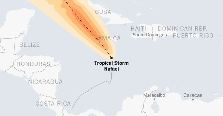
Maps: Tracking Tropical Storm Rafael

Rafael was a tropical storm in the Caribbean Sea Monday evening Eastern time, the National Hurricane Center said in its latest advisory.
The tropical storm had sustained wind speeds of 45 miles per hour. Follow our coverage here.
All times on the map are Eastern. By The New York Times
Where will it rain?
Flash flooding can occur well inland and away from the storm’s center. Even weaker storms can produce excessive rainfall that can flood low-lying areas.
Source: NOAA By The New York Times
What does the storm look like from above?
Satellite imagery can help determine the strength, size and cohesion of a storm. The stronger a storm becomes, the more likely an eye will form in the center. When the eye looks symmetrical, that often means the storm is not encountering anything to weaken it.
By The New York Times
Rafael is the 17th named storm to form in the Atlantic in 2024.
In late May, the National Oceanic and Atmospheric Administration predicted that there would be 17 to 25 named storms this year, an above-normal amount.
This season follows an overly active year, with 20 named storms — including an early storm later given the official name of “Unnamed.” It was the eighth year in a row to surpass the average of 14 named storms. Only one hurricane, Idalia, made landfall in the United States.
Typically, the El Niño pattern that was in force last season would have suppressed hurricanes and reduced the number of storms in a season. But in 2023, the warm ocean temperatures in the Atlantic blunted El Niño’s usual effect of thwarting storms.
The warm ocean temperatures that fueled last year’s season returned even warmer at the start of this season, raising forecasters’ confidence that there would be more storms this year. The heightened sea surface temperatures could also strengthen storms more rapidly than usual.
To make matters worse, the El Niño pattern present last year is also diminishing, most likely creating a more suitable atmosphere for storms to form and intensify.
Hurricanes need a calm environment to form, and, in the Atlantic, a strong El Niño increases the amount of wind shear — a change in wind speed and/or direction with height — which disrupts a storm's ability to coalesce. Without El Niño this year, clouds are more likely to tower to the tall heights needed to sustain a powerful cyclone.
Sources and notes
Tracking map Tracking data is from the National Hurricane Center. The map shows probabilities of at least 5 percent. The forecast is for up to five days, with that time span starting up to three hours before the reported time that the storm reaches its latest location. Wind speed probability data is not available north of 60.25 degrees north latitude.
Wind arrivals table Arrival times are generated from a New York Times analysis of National Hurricane Center data. Geographic locations use data from the U.S. Census Bureau and Natural Earth. Time zones are based on Google. The table shows predicted arrival times of sustained, damaging winds of 58 m.p.h. or more for select cities with a chance of such winds reaching them. If damaging winds reach a location, there is no more than a 10 percent chance that they will arrive before the “earliest reasonable” time and a 50 percent chance they will arrive before the “most likely” time.
Radar map Radar imagery is from the National Oceanic and Atmospheric Administration via Iowa State University. These mosaics are generated by combining individual radar stations that comprise the NEXRAD network.
Storm surge map Storm surge data is from the National Hurricane Center. Forecasts only include the United States Gulf and Atlantic coasts, Puerto Rico, and the U.S. Virgin Islands. The actual areas that could become flooded may differ from the areas shown on this map. This map accounts for tides, but not waves and not flooding caused by rainfall. The map also includes intertidal areas, which routinely flood during typical high tides.
Satellite map Imagery is from the National Oceanic and Atmospheric Administration and Japanese Meteorological Agency via the Cooperative Institute for Research in the Atmosphere.
Precipitation map Data for multi-day forecasts or observed rainfall totals are from the National Weather Service. The 1-day forecast is from the National Oceanic and Atmospheric Administration.


